This article covers the use of differential corrections on GPS receivers. While the example of a Garmin receiver is used the article should be generally applicable to other receivers as well. There is some data on other GPS receivers in the discussion when they differ from the way Garmin works. The following sections are included:
A: DGPS is a method of improving the accuracy of your receiver by adding a local reference station to augment the information available from the satellites. It also improves the integrity of the whole GPS system by identifying certain errors.
A: You might not, but if you want to improve accuracy beyond what is available for a consumer grade GPS receiver or want to improve integrity by knowing when to believe the receiver, one of these solutions may be right for you.
A: Most GPS manufacturers quote 17 meters (49 feet) as the accuracy of horizontal positions anywhere on earth. However, independent testing has shown that modern receivers can achieve 10 meters fairly reliably with a clear sky view.
A: A GPS can only estimate the accuracy and many manufacturers are a bit optimistic in the numbers they quote. To be more precise the Accuracy number presented is often based on a 50% to 60% probability rather than the 95% probability that is usually considered in a scientific evaluation. Note that no receiver can guarantee a particular level of accuracy without stating a probability and one of the features of some of the systems described below is to help identify when the data in the GPS might have a higher than average amount of error.
A: They are well understood and the dominant contributors are listed in this table along with the likely amount that they contribute (assuming a good sky view and reasonable satellite geometry). Note that in real life the errors may be higher than those listed in the table.
| Error | Value |
|---|---|
| Ionosphere | 4.0 meters |
| Clock | 2.1 meters |
| Ephemeris | 2.1 meters |
| Troposphere | 0.7 meters |
| Receiver | 0.5 meters |
| Multipath | 1.0 meter |
| Total | 10.4 meters |
A: A beacon based DGPS system is somewhat dependent on how close you are to the beacon, but can achieve 1 to 5 meters overall accuracy, while a WAAS system can achieve an accuracy of under 3 meters if you are located in the area where ionospheric correction data is available. A LAAS is even more accurate and can get an accuracy in the neighborhood of 1.5 meters. These are still not as accurate as survey grade receivers that receive dual frequencies, have a DGPS reference station located very close to the survey site, and use post processing techniques to reduce errors even further.
All Garmin receivers support DGPS except the Geko 101. All current Magellan receivers support DGPS except the GPS Companion as do all current Lowrance units. Many other models and manufacturers support DGPS as well.
In DGPS operation a station, often called a beacon, transmits correction data in real time that is received by a separate box, called a beacon receiver, which sends the correction information to the GPS receiver. In principle this is quite simple. A GPS receiver normally calculates it position by measuring the time it takes for a signal from a satellite to reach its position. By knowing where the satellite is, how long it takes to send the signal, and knowing the speed of the signal it can compute what is called a pseudo range (distance) to the satellite. This range must be corrected before it is used to compute the final position. Corrections such as compensation for ionospheric errors due to the fact that the ionosphere slows down the speed of travel of the radio wave is one form of correction that can be applied. A DGPS beacon transmitter site has already calculated all of the pseudo range correction data based on the fact that it already knows exactly where it is and can compute the errors in the satellite computed position from its known location. Once the pseudo range correction data is computed it is sent to the GPS and used to compute a more accurate fix. The data is sent at either 100 baud or 200 baud depending on the station and this can result in a typical delay of 2 to 5 seconds between the computation of the correction and the application of the correction. However, since most errors are slow moving this time delay is not usually a problem.
Each beacon transmitter is autonomous and computes its own corrections based on its reception of GPS signals. It then packages the correction data in groups of 3 satellites and sends the data to the GPS receiver. Note that the design of a beacon DGPS transmitter will send corrections for up to 9 satellites and these are only those at least 7.5 degrees above the horizon. The assumption is that the GPS receiver will be close enough to have the same sort of errors that the beacon station saw and they can be applied without modification to any SV's that they share a view of. This works well in practice since most of the error sources would be common between the two locations. Beacon sites have some ability to improve the system integrity as well, however there is no standard that is defined as to exactly what they can identify. They can easily identify a satellite where the required corrections exceed a prescribed value and should not be used.
It seems that Garmin will favor differentially corrected satellites when at least four exist to the exclusion of regular satellites. If the four are in a poor geometric relationship the epe number, and possibly the accuracy of the solution, can be worse than it was with a regular GPS solution.
While the major source of DGPS corrections are done via beacon transmitters operating in the 300KHz band this is not the only source of correction data. It is possible to get data from any source that can be received at your location. Some sources include FM radios using the subcarrier capability of these transmitters, the internet, and even satellites. In all cases a custom receiver (or software) is used to assemble the data in a form that is acceptable to the GPS receiver, which by standard is RTCM-104. Data conforming to this standard is then sent via the serial port to the GPS receiver on a cable. Even WAAS/EGNOS data could be massaged and delivered via standard DGPS techniques. One such system is SisNet which supplies corections via the internet.
DGPS beacon receivers capable of receiving the government corretion signal can be obtained from Garmin , from StarLink, or from Lowrance. There are probably others as well.
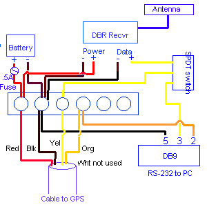
Most folks fabricate a custom cable to work with the beacon receiver. Here is a diagram for a fairly complicated version, but you may not need a setup that is this complicated depending on what else you may be doing.
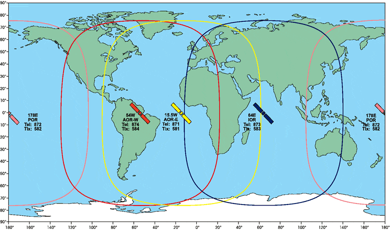
WAAS, Wide Area Augmentation System, is the latest method of providing better accuracy from the GPS constellation. It is similar in principle the the DGPS capability that is built into all Garmin and many other units except that a second receiver is not required. Instead of a beacon receiver the correction data is sent via a geo-stationary satellite and is decoded by one of the regular channels already present in the GPS receiver. Thus one of the 12 channels can be designated to decode regular GPS signals or can be used to decode the WAAS data. Actually, as currently implemented, when WAAS is enabled two channels will be dedicated to WAAS. While WAAS is the name of the implementation of this technology in the US the system is intended for worldwide use. The generic name for WAAS is SBAS (Space Based Augmentation System) or WADGPS (Wide Area Differential GPS). Since most receivers call the correction signal WAAS as a generic term this article will use WAAS in this way.
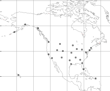
The way this works is that a set of ground stations all over the US (as shown below) collect correction data relative to the area of the country they are located in. The entire data is then packaged together, analyzed, converted to a set of correction data by a master station and then uploaded to the geo-stationary satellite, which in turn transmits the data down to the local GPS receiver. The GPS receiver then figures out which data is applicable to its current location and then applies the appropriate corrections to the receiver. Similar systems are being set up in other areas of the world but they are not yet operational.
In addition to correction information the ground stations can also identify a GPS satellite that is not working within specification thereby improving the integrity of the system for aviation use.
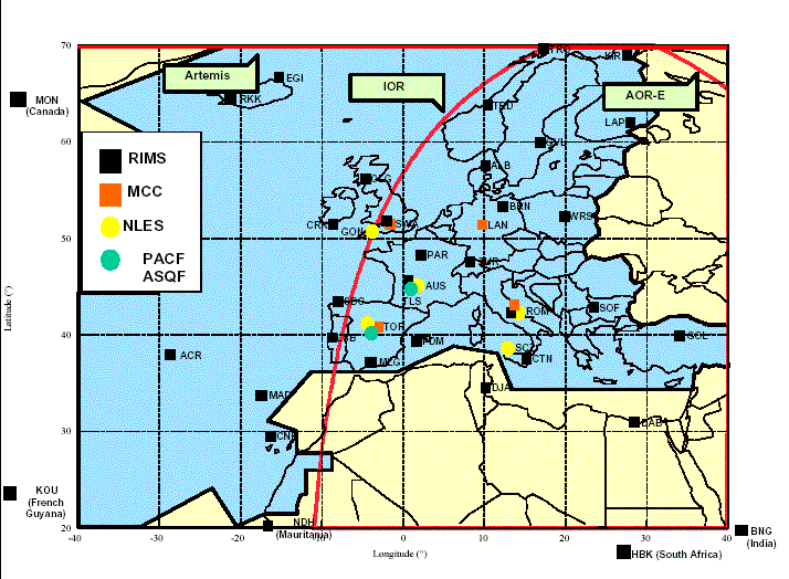
As stated, the intent is to have worldwide coverage of WADGPS corrections, however the name of the correction system varies. In Europe it is called EGNOS while in Asia the Japanese system is called MTSAT, but whatever it is called the system is designed to be compatible worldwide through a cooperative effort of member countries. The European ground station network is shown below.
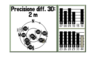 This system is still in
test mode until 2004 but is displaying correction data since April
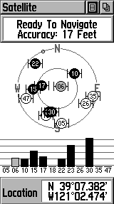
2003. The picture shows a test in 2003 with 33 and 44 representing
the two EGNOS satellites as seen on a Garmin GPS-V from a location in
Europe. When EGNOS is finally released it will use ARTEMIS as the main
satellite. A figure showing the USA
WAAS satellites on a Garmin Etrex Vista is included below.
This system is still in
test mode until 2004 but is displaying correction data since April
2003. The picture shows a test in 2003 with 33 and 44 representing
the two EGNOS satellites as seen on a Garmin GPS-V from a location in
Europe. When EGNOS is finally released it will use ARTEMIS as the main
satellite. A figure showing the USA
WAAS satellites on a Garmin Etrex Vista is included below.
The Garmin unit identifies these geostationary satellites on the satellite status screen by using numbers greater than 32. The system is still new and will be improved with more satellites in the future (possibly 19 of them world wide), however since they are all geo-stationary you will need a clear view of the southern sky to use them from the northern hemisphere. This means they are very useful for an airplane or perhaps a boat, but less useful to someone on the ground particularly in areas of tree cover or high northern latitudes. While a GPS receiver can possibly receive satellite data from outside the ground coverage area there will be very little correction capability without the correct ground data.
| Satellite | # | Garmin | ||
|---|---|---|---|---|
|
The NMEA standard WAAS labels are used by Garmin receivers. This system maps the PRN number to the NMEA label by subtracting 87 from the PRN number. (source: EGNOS help desk) The mapping from the Garmin numbers to the standard names and PRN numbers are: | AOR-E | 120 | 33 | |
| AOR-W | 122 | 35 | ||
| ARTEMIS | 124 | 37 | ||
| IOR-W/F5 | 126 | 39 | ||
| MTSAT1R | 129 | 42 | ||
| IOR | 131 | 44 | ||
| POR | 134 | 47 | ||
| MTSAT2 | 137 | 50 |
Magellan shows the geostationary satellites on the status screen
as well but does not assign them a number. Other WAAS capable receivers
may or may not show any indication of satellite reception other than
indicating a differential fix. Some units such as Garmin and Magellan
can receive up to 2 WAAS satellites while other systems may be designed
to receive only one. Once satellite contains all of the corrections for
an area while a second can be used to support redundancy or provide
reception when the other one is blocked.
Loading the Almanac
The latest released products from Garmin, Magellan, and others include WAAS capability (called EGNOS in europe and MSAS in Japan). For Garmin this includes the etrex: Venture, Legend, and Vista models as well as the GPSMap76, GPS76, and Garmin V. They have also updated some other units with this capability such as the aviation units like the GPS 295 and the Street Pilot 2610. Almost all new units Garmin have been release with WAAS support. However, unlike the standard GPS almanac that is preloaded into each Garmin receiver, the WAAS almanac is not loaded into the receiver when you get it. Each person is required to get the almanac for themselves and this is required before it can be used in WAAS mode. Some folks are able to get an almanac fairly quickly while others struggle for days and are still not able to get a successful load. Here is the technique that will result in obtaining the almanac in the minimum amount of time.
 You can reposition slightly to help the second one lock on as well but
be careful that you don't lose the first one.
You can reposition slightly to help the second one lock on as well but
be careful that you don't lose the first one.Well, now that you have the almanac data, you might be interested in what you just loaded. For a GPS the almanac data includes a coarse position data for all possible GPS SV's. Similarly the GEO almanac includes coarse position data for all possible 19 GEO satellites including the fact of their existence. The almanac will be updated as new satellites are launched but will otherwise remain static since these birds don't move much. The UTC time will also be indicated showing when the data was collected, and an ionospheric grid mask (described under how WAAS works). While locked the unit will also collect ionospheric correction data, ephemeris correction data, clock correction data, integrity data and everything else since everything repeats at least once in 5 minutes.
Similar to a beacon transmitter the WAAS system collects data from strategically placed and well characterized ground locations. However, unlike the standard DGPS a WAAS system cannot directly send corrections to the pseudorange data. This is because the unit has no idea where you are. Instead it attacks the problem by addressing the individual sources of error and sending corrections for each one of them. If you remember from the FAQ on error sources the biggest component of error is due to ionospheric delays followed by clock errors and ephemeris errors. In addition another significant error source was troposphere errors. To attack these error sources the WAAS system sends clock corrections, ephemeris corrections, and ionospheric corrections. It cannot compute tropospheric corrections due to the localized nature of this error but it does remove the tropospheric error component from the data it computes so that the local receiver can apply its own corrections based on an atmospheric model that is based on the current sky location of the SV. The ground stations do not send the data directly to a WAAS satellite for re-transmission but rather to a master ground station that analyzes the input and computes the full detailed error information. This fully correct data is then sent to the GEO satellite to be sent to the GPS receiver. Note that there is no correction done by the GEO satellite; the master ground station will even correct for errors produced by the GEO satellite itself. There are redundant master stations as well for system wide integrity.
Clock errors can change rapidly so this data is update every minute if required, ephemeris errors and ionosphere errors don't change nearly so fast so they are only updated every 2 minutes and can be generally be considered valid for up to 3 times that period of time. Even this time is very conservative in practice. Clock and ephemeris data is specific to a satellite but ionospheric errors are specific to your location therefore they must be sent separately. After receiving raw data from each of the ground station the master station divides the country into a grid and then builds ionospheric correction information on a per grid location basis from the data received from each reporting station. It is this grid location that is used by the GPS receiver to determine the applicable ionospheric corrections. In addition the master station determines the validity of the data it receives and can indicate invalid data within 6 seconds to the GPS receiver.
Of the forms of error correction supported by WAAS only the
ionospheric data requires knowledge of the receiver position. Clock
and ephemeris data is available for any receiver even if it is
currently located outside the area covered by ionospheric correction
data. In addition system integrity data can be used outside theis
area. The designers of WAAS developed a grid system of correction
data that permits a receiver to use the data it needs for this
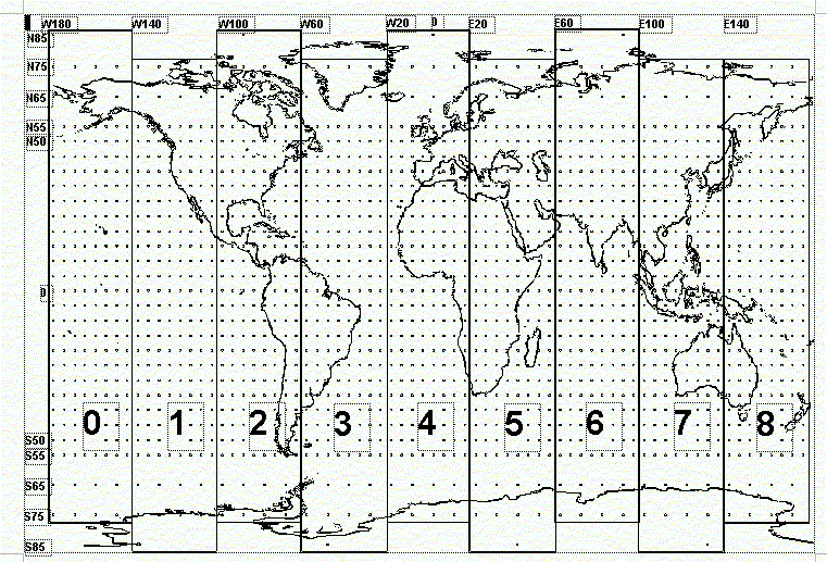
correction. Here is what the grid system looks like.
The master ground station computes a correction for ionospheric data
for each of the points on the grid based on field data it gets from
the other ground units. Of course it is very unlikely that there will
be data for all of the points on the grid over the entire earth so the
GPS receiver downloads a grid mask that is part of the almanac data
that tells it where to expect corrections. The mask is divided into
bands as shown on the drawing and each band contains 201 grid points
(except the last one which has 200). A single bit is used to
represent the availability of data on each grid point so the entire
band can be contained in a single packet of data. Each geo satellite
can have data for up to a maximum of three or four bands but may have
less. The master station will generate correction data or each of the
grid points tagged in the mask. A receiver will locate its position
relative to 4 grid points and interpolate the data from those 4 points
based on their relative distance. If only 3 points have data then the
receiver will compute a triangle of the 3 points and if it is inside
the triangle it will use the 3 points to interpolate its correction.
Otherwise, the use of any of the grid points for correction is
undefined. It seems however that most GPS implementations will use the
data from even a single point if it is "close" to the current
location. As can be seen from the map of the US
phase I implementation this is required to provide WAAS for areas such
as Alaska and Hawaii. It may be that multiple grid locations are
generated from the single data input.
In addition to correction data the WAAS system places a high degree of importance to system integrity. Each ground station and the master station has independent sources of critical data and can determine if an SV is out of calibration. Bad data can be identified and relayed to the receiver within about 6 seconds. The geosynchronus satellites that retransmit the data can even be used as regular GPS satellites as part of the regular GPS solution since they also relay regular satellite ephemeris data for themselves. This data , like all of the other data, is generated at the master station and can be turned off independent from the regular WAAS corrections if the satellite drifts too far.
All of the data for a region is loaded into the WAAS SV, so only one is required to receive everything. A second provides redundacy.
The information in this section is strictly conjecture based on study and observation. Garmin considers the inner-workings of their GPS receivers to be trade secrets so this information is not published. Note that WAAS use requires the GPS be in normal mode. Battery-save mode does not lend itself to the intermittent processing capability of battery-save mode. Generally the SV's for WAAS won't even show up in battery-save mode but it is possible to get the unit into battery-save and have it still attempt WAAS processing on some receivers but the results are unpredictable and generally not usable.
It is possible to leave the WAAS enabled all the time. The only negatives are that the unit will expend some energy attempting to lock onto the WAAS satellites and the two channels will not be available for standard GPS devices. Even a momentary break in terrain will cause the GPS to lock onto a GEO-SV if it can see one. WAAS data is sent in packets that are one second long (250 bits) and a lock can occur at any one second interval. Once locked, as shown by a grey bar on the screen) it will take some period for the GPS receiver to download enough data to be useful. How long depends on what data the GEO is sending at that moment. Often differential corrections can begin in 10 to 12 seconds from lock based on a need to download correction data for some of the SV's. The indication of correction data being present in the appearance of "D's" appearing on the regular satellite strenght bars showing which SV is receiving corrections. At this point, even if the GEO is lost again, differential corrections will continue to be applied for about 2 minutes. The WAAS specification doesn't cover the case where a GEO satellite is drifting in and out of sync with the GPS receiver since, for airplane use, a clear view of the sky is assumed. I believe Garmin is extra conservative is dropping the differential corrections after only 2 minutes. While the GEO-SV is in view the receiver will download corrections for additional SV's and the current ephemeris data for the GEO satellites themselves as well as correction data for the GEO satellites. Once ephemeris data is loaded the satellite bar will turn dark which means that it can also be used as part of the computed solution. Note that the GEO satellite can download correction data without, itself, being part of the GPS solution. A WAGPS satellite may or may not ever show a dark bar depending on the current ablitity of that SV to be used as part of GPS lock.
It seems that Garmin will favor differentially corrected satellites, when at least four exist, to the exclusion of regular satellites. If the four are in a poor geometric relationship the epe number, and possibly the accuracy of the solution, can be worse that it was with a regular solution. Luckily the GEO will generally download corrections for all of the satellites above a mask angle of 5 degrees so this anomaly is usually short lived. However, if the WAAS lock in on a geo satellite that is outside the coverage area for that particular SV the results can be differential corrections based on ephemeris and clocks on SV's that are all located in one corner of the sky which, because of poor geometry, can result in worse solution. In this case the only recourse is to turn off WAAS. All of the latest firmware releases from Garmin correct this potential problem by checking the coverage area before a lock is permitted on the WAAS satellites.
If a GEO drops behind a hill the GPSr will lose its information just like any other GPS satellite. When the vehicle moves far enough the GEO may be seen again and will recover with its ephemeris data still current and re-enter the solution but it seems that ephemeris data on a GEO is shorter lived that on a normal GPS where it is good for hours. I observed a loss of geo satellite dark bar status after only about 2 minutes of it being out of sight. It could be that ephemeris data on a GEO is short lived since it tends to wobble a bit and is not truly in a circular orbit having much more eccentricity that a normal gps satellite or it could be that the GEO had been reset due to some ongoing test mode. More data will be required to determine which.
If you receive a satellite but do not have any ionospheric data for your area the Garmin receivers with the latest firmware do detect this condition. They will not lock on a WAAS SV outside its coverage area. I think they should lock if no other WAAS capable SV covers the area and use the corrections for clock and ephemeris available while applying the internal ionospheric correction algorithm in this case but they don't seem to be this sophisticated.
Other GPS receivers may or may not detect this condition. In
some cases they may receive data and use it for corrections but not
support the ability to use the GEO-SV as a GPS satellite. While many
receivers claim support for WAAS these days the implementation may
not be the same in all receiver designs. For example, receivers
using the SiRF chipset will only devote one channel to WAAS reception.
Magellan use of WAAS
Magellan uses WAAS in a similar way to the description of Garmin
use given above. However they do not have a menu item to turn WAAS on
or off. There is a secret menu entry that can do this. Turning off
WAAS frees up some channels for regular satellite use and should
certainly be performed if you are outside a WADGPS coverage area. As
already mentioned Magellan does not display the WAAS satellites on the
satellite status screen so there is no indication on the unit whether
WAAS is turned on or off unless you are actually receiving WAAS
signals. When you are receiving WAAS the epe indication changes to
show WAAS and when averaging a position the WAAS indication is
present. Note that the unit will continue to use WAAS corrections long
after the signal is lost. Some report that corrections will be used
for 50 minutes or longer as indicated by the WAAS averging
indication. (It is not clear from the report that WAAS data is still
being used or it is just a software bug.) If you power the unit down
and back up the use of this stale data will be discontinued.
Internet Corrections
WAAS/EGNOS systems rely on geostationary satellites to supply the correction information. Unfortunately these satellites are not always visible or usable to GPS receivers in urban canyons or high latitudes. To solve this problem the egnos group has developed an internet solution called SisNet which provides the correction information via the internet. A wireless GPS system such as one that is attached to a wireless enabled PDA could collect the information from the internet and then supply it to a regular GPS using standard DGPS correction techniques. In this use a WAAS/EGNOS capable receiver is not required but a specific software implementation would be needed.
For standard beacon receiver corrections you might be able to use
Wolfgang's
DGPS or for a commercial solution check with Networked
Transport. This NTRIP product offers both server and client
software for various platforms.
Local Area Augmentation System
LAAS is similar to both the beacon approach and the WAAS approach. It uses a separate transmitter that operates in VHF frequencies and then sends the update data to a compatible gps receiver. It includes both increased accuracy and increased error detection over that obtained from either the gps receiver or WAAS and is accurate enough to provide data for use in landing a plane. Unlike the other systems mentioned the very local nature of LAAS means it is likely only going to benefit aircraft and will not be effective for other users.
Since the LAAS reference station is expected to be close to the plane it can correct for most gps error sources. It even tackles the issue of multipath errors by integrating the data from several (up to 4) ground stations and providing a single correction package for pseudorange data. Troposhperic errors should be common between the site and the plan so corrections include this data. Similar to the methods used by WAAS the LAAS system has built in error detection as well as correction and can reject a solution from a bad satellite.
The focus of LAAS is to provide a standalone system that is separate
from the gps receiver (but likely sharing the same external antenna).
It has a display that mimics the atandard aircraft display and it is focused
on landing data. However there is no reason the LAAS data could not be
reduced to pseudorange correction data in a format identical to the
beacon receiver format and then used with a standard gps receiver identically
to the way dgps corrections are done today. To make this work the gps
would need to allow the RTCM correction data to override the WAAS
data. It will be very accurate correction data and provide a backup to
the LAAS hardware.
Commercial Solutions
In addition to the Augmentation systems listed above there are also systems designed and built by commercial vendors. These are usually referred to as WADGPS systems. These vendors are not just retransmitting government correction signals but have their own ground stations and satellite links very much like the WAAS/EGNOS system. However the corrections generated are more like the beacon dgps system described above in that they send full corrections for pseudo range data. Customers include farmers needing precision positioning to provide tractor guidance, crop dusting, and some surveying activities.
One such system is Omnistar. This system can provide dgps correction for a standard GPS receiver but for highest accuracy they require that you use a full standalone GPS implementation. They, of course, make and sell such a system but systems can also be obtained from NovAtel.
Another competing system is from NavCom using the John Deere Starfire system.
The information in the WAAS section is derived from the FAA technical specification, available from the FAA web site, the European EGNOS sites, other sources, and personal observation. The US Coast Guard web site provided some of the information in the beacon section. Other sites used for reference are indicated in the text. The LAAS data is also from the FAA site. I have no direct experience on LAAS.
by Dale DePriest - all rights reserved
Preliminary post 01/04/24
Updated slightly 01/04/30.
A few more updates on 01/05/16
Some more LAAS stuff. 01/6/16
added US and Europe Maps and updates some data 02/1/12
added some Garmin observations 02/07/18
added some commerial links 03/04/04
added more EGNOS data 03/06/27
updated EGNOS map and WAAS discussion based on latest Garmin
firmware release 03/08/08
added some Magellan stuff 03/11/22
added Garmin - satellite table 04/02/14
added internet section - 04/02/28