• skip to content

rigacci.org

User Tools

  • Log In

Site Tools

  • Recent Changes
  • Sitemap
Trace: • 2005/04/12 risponde Sepp Kusstatscher • Questionario sul futuro sistema di brevetti europeo • Ricette Mappe OpenStreetMap • 2005/03/16 e-mail a Lucio Stanca • OpenLayers: modificare gli stili • GPS, cartografia e GIS

Sidebar

No ai soldati italiani all'estero

Indice

  • Doc
    • Appunti Wiki
    • Biblioteca on-line
  • Tecnica
    • Download
    • Free Software
    • GPS, cartografia e GIS
    • Hardware
    • Motori e due ruote
    • Sicurezza Informatica
  • Attualità
    • Consigliere 5 Stelle
    • Guerra
    • Libertà digitale
    • Varie
  • Niccolo@Rigacci.Org

PayPal donation

Software libero!

OpenStreetMap

Debian

www.gnu.org

www.kernel.org

tecnica:gps_cartografia_gis:start

Table of Contents

  • GPS, cartografia e GIS
    • Apparati GPS
    • Appunti e letture
    • Download dati e consultazione mappe
    • Altre letture
    • Foto

GPS, cartografia e GIS

Global Positioning System
Geographical Information Systems

Apparati GPS

  • Garmin eTrex 10
  • Ricette Mappe OpenStreetMap - Le mappe OpenStreetMap sul Garmin eTrex 10
  • Garmin eTrex 10 Cheat Sheet
  • Garmin Foretrex 201 GPS
  • MTKBabel Download GPX data from MediaTek MTK logger

Appunti e letture

  • Ricette Mappe OpenStreetMap
  • OpenStreetMap.org
  • Appunti sparsi
  • Glossario GIS
  • Ricette GIS
  • Riferimenti web
  • PostGIS
  • MapServer
  • Oltre MapServer
  • Il formato GPX
  • Simulare un GPS via gpsd o via seriale
  • Guida al GPS, in italiano
  • Installazione software su Debian
  • Installazione MapServer su Fedora Core
  • GetFeatureinfo: query su WMS
  • Raster con GDAL e MapServer
  • Conversione da Gauss-Boaga Roma40 a WGS84
  • Sistemi di riferimento geodetici

Download dati e consultazione mappe

  • Progetto Strade
  • Pagina per il download dei dati raccolti e rielaborati qui da noi
  • Mappe per il Progetto Strade
  • Colonne Leopoldine in Toscana

Altre letture

  • Making Maps Easy to Read
  • http://www.slashgeo.org/ News and discussions about GIS and everything geospatial

Foto


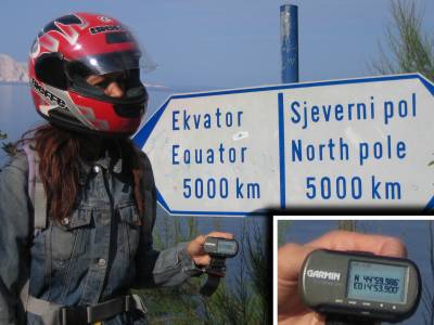
Datum shift al 45° parallelo.

tecnica/gps_cartografia_gis/start.txt · Last modified: 2020/04/05 09:44 by niccolo

Page Tools

  • Show pagesource
  • Old revisions
  • Backlinks
  • Back to top
Except where otherwise noted, content on this wiki is licensed under the following license: CC Attribution-Share Alike 4.0 International
CC Attribution-Share Alike 4.0 International Donate Powered by PHP Valid HTML5 Valid CSS Driven by DokuWiki